polis: a collective blog about cities worldwide

Visualizing a Walkable City

by Eduardo Ares


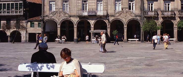
A public square in Pontevedra, Spain. Source: Turespaña

The city of Pontevedra in northwest Spain has become a leader in walker-friendly urban policy over the past 15 years. In light of its relative anonymity and population of 83,000, one might find it difficult to imagine the traffic congestion that prompted this transformation. However, as the capital of its province, county and municipality, Pontevedra attracted enough automobile commuters each day to overwhelm its antiquated streets.

Instead of razing old buildings and constructing bigger roads, the city council began taking proactive measures to reduce traffic. They widened sidewalks, established a free bike-lending service, installed speed bumps and set a speed limit of 30 kilometers per hour throughout the city. They even banned motorized transport in sections of Pontevedra. Walking zones now extend from the historic center to streets and squares in newer neighborhoods. Although the driving ban initially faced resistance, it is now broadly supported and has become an essential part of the city's identity as an attractive place to live.


Pontevedra's Metrominuto Map. Source: Pontevedra City Council

To further improve walkability, Pontevedra's city council produced a map that visualizes the distances and travel times between key places on foot at an average speed of five kilometers per hour. Known as Metrominuto, the map has color-coded lines that resemble those of a subway guide. The pink line from Peregrina Square shows that it takes about 14 minutes to walk from there to the train and bus stations. Free parking areas are marked to encourage visitors to leave their cars outside the city center. According to the map, someone who parks in the free lot near the police station can get to Peregrina Square in less than eight minutes via Santiago Bridge. Metrominuto reminds residents and visitors that many automobile trips can be made in a more convenient, environmentally friendly and healthy way by walking.


A banner listing distances and travel times from the Metrominuto Map. Source: Eduardo Ares

The Metrominuto initiative recently won an award from Intermodes, the organizers of an international transport convention for the European Congress, who explained: "Metrominuto is an idea that can be easily transposed in cities that have 80,000 inhabitants (or less), of which there are more in Europe than there are very large conurbations." Pontevedra's urban restructuring program has also earned accolades from the Spanish Committee of Representatives of Persons with Disabilities and the Spanish Directorate General of Traffic.

Pontevedra's walker-oriented initiatives raise questions as to how they came into being and how they've influenced living conditions in the city. Researching these questions should tell us whether Intermodes' recommendation is warranted, offering insights into the potential for similar initiatives in other cities around the world.

Eduardo Ares is a doctoral candidate in computer science at the University of A Coruña in Galicia, Spain.

+ share

Planning Karma in Chandigarh

by Jordi Sánchez-Cuenca

The city of Chandigarh was conceived by Jawaharlal Nehru, the first prime minister of independent India, as capital of the state of Punjab after its bloody partition in 1947. Construction of Chandigarh began in 1952, based primarily on a design by iconic modernist architect Le Corbusier. Chandigarh is now the capital of two Indian states while remaining a union territory, which means that it is under direct control of the central government.


Central Chandigarh.

Le Corbusier was a steadfast proponent of rationally planned cities with clearly defined zoning. He believed that residential areas should be separate from large roadways in the form of "superblocks" with multistory apartment blocks, ample green space and relatively self-sufficient local economies. The construction of Chandigarh turned out to be his first and only opportunity to see these ideas applied at the scale of a city. A 1963 article in the Harvard Crimson describes Chandigarh's housing plan:
Its central units are residential sectors of approximately 240 acres, designed to house 15,000 people. Each is an inward-looking, self-contained neighborhood, with its own business center. The city can be expanded almost indefinitely by adding new sectors; yet, growth will not lead to depersonalization, Le Corbusier believes, for each sector forms a coherent community.

Le Corbusier's original plan. Source: STUDYBLUE

Today Chandigarh has the top Human Development Index (HDI) ranking of all Indian cities, and the third highest per capita income after falling from first place in 2009. It also has the best sanitation system according to a recent study by the Indian Ministry of Urban Development. Its high standard of living is one of many parallels with Brasilia, Brazil, another capital city built after World War II based on a famous modernist plan. Can this standard be attributed simply to the concentration of capital in centers of political power? Have the historic plans played a role?


Chandigarh Secretariat. Source: Wikimedia Commons

Le Corbusier, despite his talent and expertise, could not predict or control the way cities develop over time. Despite Chandigarh's wealth and cleanliness, there are large informal settlements in the area where people live in extreme poverty. Satellite images show a sharp contrast between planned and unplanned territories.


Chandigarh's Sector 1 (bottom) and the village of Kansal (top).


Colony No. 5, one of the Chandigarh's largest informal settlements.

There is currently an ambitious plan in the works to make Chandigarh a "slum-free city," part of the Jawaharlal Nehru National Urban Renewal Mission (JNNURM) launched by the Ministry of Urban Development in 2005. The JNNURM includes a focus on "[p]rovision of basic services to the urban poor including security of tenure at affordable prices, improved housing, water supply and sanitation, and ensuring delivery of other existing universal services of the government for education, health and social security."Although the initiative is running behind schedule in Chandigarh, it appears to be a promising departure from past "slum clearance" policies based on forced evictions.

Credits: Satellite images from Google Earth.

+ share

Will ‘EuroVegas’ Bring Prosperity to Madrid?

by Melissa García Lamarca


Alcorcón, a quiet suburb of Madrid, is poised to begin transforming into "EuroVegas" by the end of the year. The controversial project consists of hotels, conference space and entertainment around a replica of New York's Times Square. Last week, Las Vegas Sands Corp. — headed by Sheldon Adelson, the 14th richest person in the world — announced financing of $13.1 billion to begin construction, accompanied by flashy renderings of the planned development.


Madrid won the project over Barcelona in a heated competition last fall, and the site in Alcorcón was selected early this year. The development would include six casinos with 18,000 slot machines and 1,000 gambling tables, 12 hotels featuring a total of 36,000 rooms, a convention center, three golf courses, bars, restaurants and shopping centers on a 750-hectare site — all for a total of $35 billion.


The sky is literally the limit for EuroVegas. A "specially approved law" allegedly suspended height restrictions on buildings in the complex, one of many attempts by public officials to encourage Adelson to invest. Las Vegas Sands is to receive tax breaks on gambling revenue and property value as well as fee reductions on construction and infrastructure; there has also been talk of allowing smoking in some of the buildings despite a nationwide ban.


One of the major selling points is job creation, as Spain's unemployment rate hovers around 26 percent. Adelson claims that the project will generate over 250,000 jobs, which would reduce unemployment in Madrid by almost half. However, the actual quantity and quality of employment remain unverified. It is also unclear who would benefit, as public officials reportedly expressed openness to lifting restrictions on foreign workers to push down labor costs.


A protest banner reads "ANOTHER LIE. ANOTHER SCAM. NO EUROVEGAS." Source: El País

The protest group EuroVegas No questioned the development's potential benefits in a recent statement: "What guarantees do such supposed jobs have? Beyond these baseless claims, it is to be expected that EuroVegas is only beneficial for a privileged minority and will provoke irreversible environmental damage in the region." In light of popular frustration over neoliberal economic policy and corruption, the project will likely face continuing opposition from those who envision a different kind of prosperity for Greater Madrid.

Credits: Renderings are from EuroVegas Madrid.

+ share

15 Points About the Underbanked

by Melanie Friedrichs


Source: The East African

Definitions


"Underbanked" is a bit of a buzzword in the financial services industry, but it rarely finds its way into popular culture. Different definers offer different definitions, but the most authoritative is that of the Federal Deposit Insurance Corporation (FDIC), whose National Survey of Unbanked and Underbanked Households defines it consistently in relation to "unbanked":

1. Unbanked: "Households that do not have a checking and/or savings account."

2. Underbanked: "Households that have a checking and/or savings account and have used non-bank money orders, non-bank check cashing services, non-bank remittances, payday loans, rent-to-own services, pawn shops or refund anticipation loans (RAL) in the past 12 months."

In casual language, the term "underbanked" usually refers to the "underserved" — individuals or households who don't fit neatly into the conventional financial services landscape. I offer a broader definition:

3. Underserved: The unbanked, the underbanked and all consumers who can't access credit because of poor, thin or no credit files, or face some other barrier to accessing financial markets.

Demographics


Charts tell this story better than I can:

4. One in four U.S. consumers are unbanked or underbanked:


2011 banking status of U.S. households (percent). Percentages are based on 120.4 million U.S. households and may not sum to 100 because of rounding. *These households are banked, but there isn't enough information to determine if they're underbanked. Source: "2011 National Survey of the Unbanked and Underbanked Households" by the FDIC


5. The unbanked are disproportionately minorities:


Unbanked households by race. Source: "2011 National Survey of the Unbanked and Underbanked Households" by the FDIC

6. Cities: According to the FDIC National Survey: "Larger proportions of unbanked households are located in urban areas than other banking status groups. The largest share of unbanked households (41.2 percent) are concentrated in urban areas, while only 30.9 percent of underbanked and a quarter (25.5 percent) of fully banked households live in urban areas."

Reasons


7. Distrust: On Friday I ran into an acquaintance on the train to Boston and, when I pulled out my debit card to pay for my ticket, he remarked that he doesn't do that anymore. He had pulled his money entirely out of the system to avoid supporting big banks. While he is in a small minority, aversion and distrust are important reasons for the high percentage of underbanked. And distrust works both ways, as risk aversion and fear of default leads some institutions to tighten their lending rules.

8. Low rates, high fees: Both the public perception and the value proposition of financial institutions right now are near rock bottom. The Federal Reserve's "quantitative easing" measures drove down lending rates, the primary source of revenue for banks and credit unions, which in turn led to higher fees and lower deposit rates. Consumers now have to search for a deposit account that will earn them money instead of costing them money.

9. Regulation: Regulation isn't designed to hurt the underbanked, and some regulation, such as the 1977 Community Reinvestment Act, is specifically designed to help. Regulation is, however, designed to catch money-launderers and identity thieves, and reduce systemic risk. Identity verification and "Red Flag Rules" strengthened under the Patriot Act can prevent applicants with thin credit files — mainly young people, recent immigrants and low-income workers — from opening even a basic checking account. Basel III liquidity requirements may cause some banks to lend more conservatively, and Consumer Financial Protection Bureau (CFPB) oversight may cause them to raise fees to cover compliance costs. Talk about unintended consequences.


Source: Bankless Times

Solutions


The "traditional" way to serve the underbanked is through Alternative Financial Services (AFS), including check-cashing, payday and tax-refund loans, rent-to-own agreements, subprime mortgage and auto loans, as well as person-to-person lending. Although not exploitative by rule, AFS have a bad reputation because need-based leverage, informal operations, local monopolies and information asymmetry allow AFS providers to charge high fees or lock the underbanked into burdensome debt agreements. I know of three interesting ways to serve the underbanked outside of AFS:

10. Alternative data: As mentioned above, many of the underbanked have thin credit files, which cause problems with identity verification and sometimes make them "unscorable" by credit data reporting agencies. Loan applicants with no credit score are usually denied credit, creating a Catch-22 in which applicants without credit history can't get credit history. It is possible to incorporate alternative data sources, including utility payments, phone bill payments, rental payments, remittances and other non-payment data into credit scores. A number of companies started packaging alternative data for financial institutions in the 1990s and 2000s with limited market penetration, but in the past few years supporting research by advocacy groups and careful integration of alternative data by major credit reporting agencies has helped bring alternative data into the mainstream.

A graph from the Policy and Economic Research Council (PERC) shows credit scores with and without the use of alternative data:


Distribution of credit scores for all consumers in sample with and without utility payment data and for those consumers with only utility payment data. Source: "Using Non-Traditional Data for Underwriting Loans to Thin-File Borrowers: Evidence, Tips and Precautions" by Michael Turner and Amita Agarwal

Incorporating alternatives to financial-institution payments into the score can help underserved consumers access credit. For more information, see "Give Credit Where Credit is Due: Increasing Access to Affordable Mainstream Credit Using Alternative Data" from PERC and the Brookings Institution Urban Markets Initiative.

11. Prepaid cards: Prepaid cards evolved from gift cards and government Electronic Benefit Transfer (EBT) cards as a way to pay unbanked employees. Private prepaid card providers emerged in the early 2000s, in some cases charging high fees and engaging in exploitative practices similar to those associated with AFS. Prepaid cards have generated much speculation recently with the launch of prepaid cards by major companies, most notably Bluebird by American Express and Walmart. For more information, see "Cards, Cards and More Cards: The Evolution to Prepaid Cards" from the Federal Reserve Bank of St. Louis.


A few popular prepaid cards on the market today. Source: Melanie Friedrichs

12. Mobile banking: Recently, a number of organizations and publications have touted mobile banking as a way of serving the underbanked. Many underbanked consumers have mobile phones — more than the number who have a personal computer or home Internet connection among some demographics. Mobile allows low-income consumers to access key financial services at a low cost, and also integrates with personal financial management tools to encourage smart spending and "financial capability." It also provides opportunities for peer-to-peer payments and peer-to-peer lending. For more information, see "Reaching Underbanked Consumers Through Mobile Services" from Celent and the Center For Financial Services Innovation.

So What?


Definitions, demographics, reasons and solutions are of little use without a reason to care. Many consumers who distrust banks may simply say good riddance. For banks, the demographics of the underbanked tend to overlap with the demographics of their least profitable and highest risk customers. So why, apart from an ethical appeal to equal opportunity, should we care about the underbanked?

13. Lifetime value: "Fortune at the bottom of the pyramid" aside, the underbanked have long-term potential greater than their short-term appeal. And remember, we're not talking about a few customers who slip through the cracks; we're talking about a full quarter of the population. Financial institutions of all stripes today are eager to lend, and offering credit to an underbanked but responsible consumer who would have otherwise used AFS can benefit both parties.

14. Catalyst for change: Cost-effectively serving the underbanked requires out-of-the-box thinking to lower the cost and increase accessibility of transaction services. Luckily, this is exactly the kind of thinking that banks should be doing anyway. Alternative data, prepaid cards and mobile banking are all tools that banks and credit unions can use to improve their service offerings substantially.

15. Macroeconomics: Standard economic theory says that entrepreneurs need access to financial services to obtain funds to innovate. Exclusion from financial services prevents would-be small-business owners from starting out and growing; it may also prevent the underbanked from pursuing higher education. Similarly, the burdensome interest rates and high transaction fees of AFS keep the underbanked in poverty, which hurts the economy and society at large.

+ share

Revisiting Street Art in Milan

by Vivien Park


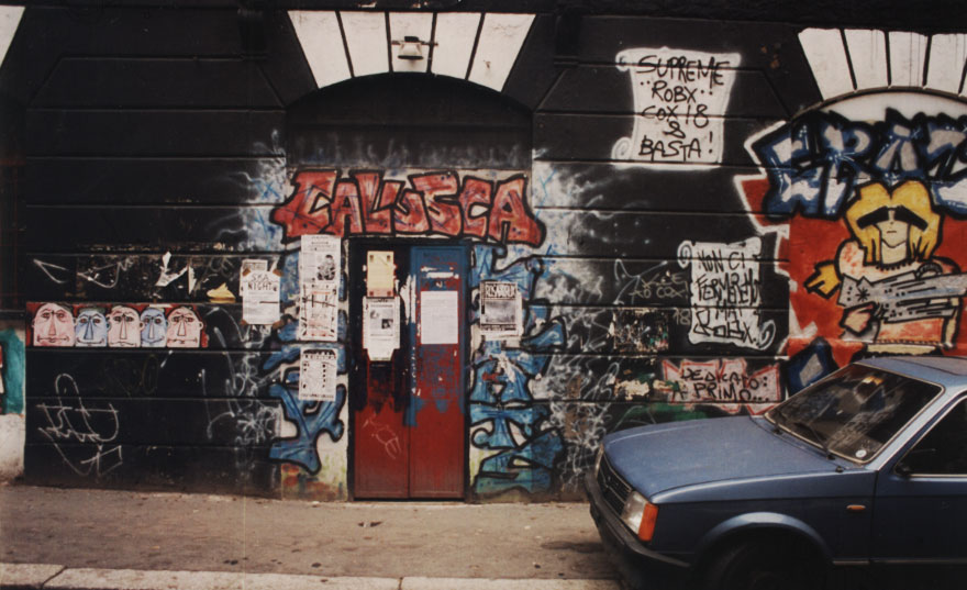
Graffiti at 18 Via Conchetta in Milan, 1992.

In the early 1990s, Alberto Boido started taking pictures of graffiti in the streets of Milan. He now returns, twenty years later, to photograph each site from the same angle. Some paintings are still visible, while others have been completely covered.


The same wall at 18 Via Conchetta, 2012.

Boido posts the before and after shots to a site called the "Old Walls Project," a tribute to the changing walls that have inspired him over the years. He also plots each location on an interactive map.

For anyone who's noticed the same graffiti in Milan, Boido's site offers a chance to retrieve these memories. Even for those of us who haven't seen the paintings, his pictures vividly highlight changes in the urban fabric over time.

Credits: Photos by Alberto Boido.

+ share

Hurricane Sandy: An Artist’s Story

by Leon Reid IV

As Hurricane Sandy moved up the East Coast, Mayor Michael Bloomberg ordered an evacuation of all New York City flood zones, just as he had done before the arrival of Hurricane Irene last year. Because Irene swept through after so much hype and left the city in decent shape, it seemed we were preparing for another false catastrophe.


My art studio overlooks Newtown Creek, a serene but highly polluted channel separating Brooklyn from Queens. It also happens to be in Flood Zone A — the zone with the highest risk of inundation. Walking around the building, you can see why. The elevation drop in the courtyard is like a cobblestone stairway down to the water. My studio was always considered prime space because it's relatively high on the incline. Hurricane Irene poured only a quarter inch of water on parts of the floor.

In the months before Sandy, I was working on a sculpture called "American Debt." It is of a human under the crushing weight of a credit card. I splurged on the materials, purchasing 23-karat gold leaf to gild the casts of my own credit card. By late October, the human figure was cast, the steel display plates were cut and the gold leaf was blinging. All that was left to do was attach the elements together.


As Sandy raged through New York, I saw images on the news of the Lower East Side with cars submerged in water. I sat in Brooklyn with my wife and newborn baby, refreshing CNN's homepage and listening to The Brian Lehrer show on WNYC. Someone called in and said they saw police and firemen rescuing someone from Newtown Creek. Thoughts of the destruction kept me up most of the night.

When I arrived at my studio the next morning, the superintendent said, "Damn Leon, you got it bad. Everybody did." He pointed to a faint dark line running halfway up the doorway. "That's how high it got." He hurried away to tell someone else the bad news.

I unlocked the door and opened it about an inch. A wood box that had been in the back corner of the studio now jammed the doorway. I finally forced the door open and entered into a dank, foul-smelling nightmare. The floodwater had risen over four feet high. The few untouched objects were trivial: spare wood stored in an overhead rack and some shelving units with ear plugs and bathroom cleaning supplies.


"American Debt" was waterlogged and scattered among everything else that mattered. I found four of the five cast figures and three of the five gilded credit cards. The gold leaf sat wrinkled in a puddle. The steel display plates fared even worse. Heavy rust had developed on all five, and they looked like they'd been recently uncovered at an archaeological site. Fortunately, all the sculptures were salvageable, but not without considerable cost. Some works, including "The Hundred Story House," didn't survive.

A relative from New Orleans called and suggested applying to FEMA for disaster relief. My wife researched the agency and found that they offer loans for businesses affected by natural disasters. But, having spent so much time on a piece about debt, I wasn't keen on incurring any more than I have already. There had to be another way.

Today you can walk into my studio and never know it had been flooded. Thanks to the support of friends, family and several art groups, I was able to complete "American Debt" and recover from Sandy without resorting to credit. This distinguishes my story from those of so many others across America who've survived disaster only to face a rising tide of debt.

Leon Reid IV is a Brooklyn-based public artist. He is currently working on a project called "A Spider Lurks In Brooklyn."

+ share

Environmental Injustice in Delray

by Matt Friedrichs

For those who see America as a land of justice for all, I recommend visiting the Delray neighborhood in Detroit. Its boarded-up buildings reflect a steadily decreasing population, as people flee unhealthy living conditions brought on by years of heavy industry. Still, there are many who call Delray home. Of the neighborhood's 2,689 reported residents, approximately 28 percent are under 18 years old and 43 percent are living below the poverty line.

Brasilia’s Uneven Development

by Jordi Sánchez-Cuenca

The city of Brasilia took shape on a relatively isolated plot of open land in 1956, becoming the capital of Brazil in 1960. The city was planned by Lucio Costa, winner of a competition called by President Juscelino Kubitschek to fulfill an 1891 constitutional mandate to move the capital from Rio de Janeiro to a location at the center of the country. Oscar Niemeyer was the principal architect, and Roberto Burle Marx was the principal landscape designer.


Bird- or airplane-like form of Brasilia, Brazil.


Original city plan by Lucio Costa. Source: Jader Resende

Brasilia was built according to plan, with few modifications. It is a modernist dream come true, a gigantic piece of land art. It is now one of UNESCO's World Heritage Sites, and the municipal government invests in keeping its monuments in good condition. Brasilia was designed for automobile transport, with no traffic lights and few sidewalks in the center. Avenues are massive to prevent traffic jams.


Southern wing of the city — satellite view (above) and perspective (below).


Source: Arqpoli Urbano

As with other planned cities, Brasilia grew larger than predicted. It is now surrounded by smaller cities and settlements that provide cheap labor for the wealthy capital. Urban growth in the periphery did not follow a modernist plan. Most of these residential areas grew through land speculation and informal construction.


High-income Lago Sul neighborhood in central Brasilia.


Low-income Sol Nascente neighborhood in Ceilândia, 26 kilometers west of the capital.

Brasilia has the highest per capita income of Brazil's major cities. Its social disparities are spatially divided, with a wealthy center and impoverished outskirts. In Sol Nascente — one of the country's largest informal settlements according to census data from the Brazilian Institute of Geography and Statistics — garbage collection, sewage and healthcare are severely limited. And, as in many cities around the world, government neglect gives rise to illegal land markets and associated mafia activity.

Brasilia's metropolitan area demonstrates perhaps the sharpest possible contrast between state-controlled wealth at the core and informal poverty on the periphery.

Credits: Satellite images from Google Earth.

+ share

New Life for Empty Lots in Zaragoza

by Teresa García Alcaraz

"Esto no es un solar" (this is not a lot) is a participatory design project reanimating abandoned lots in Zaragoza, Spain. The municipal government started the project in 2009 to clean up the historic center and reduce unemployment. Lead architects Patrizia di Monte and Ignacio Grávalos Lacambra have focused on collaboration with neighborhood residents in generating and realizing ideas for each space.


The project has since expanded beyond the historic center to 28 sites throughout the city. Each repurposed lot has a number and is plotted on a map, linking it with the others. In all, they make up 42,000 square meters of space transformed into many different kinds of community gathering places.


Plot 1, an urban garden that includes benches and parking for bikes. Source: todo por la praxis

The lots have become playgrounds, parchís boards, gardens, small woods, volleyball pitches, pingpong sites, pétanque courts and resting places for the elderly. They are all free of charge and freely accessible to all.


Plot 5, a playground with a giant parchís board painted on the ground. Source: esto no es un solar

The name "this is not a lot" encourages people to imagine what can happen in each space, proposing new projects and creating places that they care about. Anyone can post comments and ideas on the program blog to communicate with others in the community. Over 50 organizations — including schools, neighborhood groups and cultural centers — have participated in the program.


Workers with T-shirts that create playful sentences. Source: esto no es un solar

While building and painting the sites, workers wear T-shirts that display a single word from the program name. Together the shirts form random sentences like "un solar no es un solar" (a lot is not a lot), "esto es" (this is) or "un solar no es esto" (a lot is not this). The work becomes a community event that encourages people to meet their neighbors and feel a sense of ownership over the site.

At the same time, the program has run into problems with longterm maintenance and doesn't appear to be providing substantial employment. But if the municipal government is able to sustain adequate support, "this is not a lot" should continue to improve in aligning urban development with the wishes of local residents.

+ share

Simplifying New York Parking Signs

by Min Li Chan

In part five of our series on urban typography, we turn our attention to the universal problem of complicated parking signs. With their convoluted restrictions and temporal conditions meted out in uppercase authority, they almost seem designed to guarantee a constant stream of revenue from parking tickets.

New York's transportation commissioner Janette Sadik-Khan recently observed that the city's parking signs "can sometimes be a five-foot-high totem pole of confusing information."


Source: Park It! Guides

The design firm Pentagram recently worked with New York's transportation department to redesign the city's parking signs. The new versions are left-aligned for readability, consistently color-coded and clearly spaced. They are also streamlined to two flavors: one for commercial vehicles, one for all other vehicles. A logical and consistent information hierarchy conveys the most important parts first, matching the cognitive flow of a motorist trying to determine whether she is parked legally.


Source: Pentagram

Each sign begins with the type of parking available, followed by important notices and the period of enforcement. The previous signs counterintuitively displayed the time before the day of the week. By comparison, the simplified signs are a breath of fresh air.

Polis readers, if you have examples of what delights or frustrates you about parking signs in your city, we'd love to hear about them!

+ share

Scenes from an American Nightmare

by Rebecka Gordan

Over the past three years, photographer and filmmaker Eve Morgenstern has been working for the U.S. Federal Reserve to document homes lost during the foreclosure crisis. Her pictures from cities like Phoenix, Detroit, Buffalo and Las Vegas offer striking testimony to abandoned dreams.


In an interview on the Swedish radio program Kulturnytt, Morgenstern said that visually documenting foreclosed homes provoked her to "rethink what the American Dream really means."


She noticed that boarded-up windows and for-sale signs became catalysts for decline, explaining on Kulturnytt:
What I learned going to all these cities is that as soon as a home becomes foreclosed, the bank puts up plywood, the wood over the windows. And as soon as this happens, it is amazing: It becomes an eyesore in the community, and it completely shifts things. The value of the houses goes down, crime goes up, vandalism. It becomes this domino effect immediately as soon as the front of the home begins to change.


Empty houses create a sense of despair that influences the fate of entire neighborhoods, as the dream of home ownership becomes a nightmare. Each facade is surprisingly human in its unique condition, calling to mind its former owners. What became of them?

Morgenstern's pictures are currently on display at the Bildmuseet in Umeå, Sweden.

+ share

Poverty Below the High Line

by Sahra Mirbabaee


The High Line. Photo by Iwan Baan for James Corner Field Operations. Source: Elitism

Of all the factors that contribute to urban livability — including public health, education and infrastructure — policy is often focused disproportionately on economic growth. In pursuit of this assumed prerequisite for prosperity, municipal governments around the world are investing in urban design. At the same time, this investment is fueling inequality and displacement. The allocation of public funds to places of high economic potential favors the rich, creating an unfair playing field for all tax-payers. One of the most striking examples of this trend is the High Line in New York City.

Built on an elevated former railway, the High Line park runs 1.45 miles along Manhattan's West Side. Since the 1990s, the surrounding neighborhoods have changed from a downtrodden post-industrial area to a hot spot in the city's social and cultural scenes. They're now home to many bars, galleries, restaurants and shops like Barneys, Alexander McQueen and Stella McCartney. Past neglect created the conditions for profitable redevelopment, as evident in "Alphabet City" and many other Manhattan districts over the past 20 years.

Since its opening in 2009, the High Line has been hailed as an inspiring use of architecture for urban renewal. It has a large fan-base, including the municipal government. In fact, the High Line has thrived "within the confines of the community of money" because of strong government support. The first two installments cost a reported $152.3 million, and the third is projected to cost $86.2 million. Funding sources comprise $112 million from the city government, $20.3 million from the federal government, $400,000 from the state and $44 million from private donations. Operating costs are estimated at $2-4 million per year. With over half the High Line's budget coming from public funds, concerns over the return on this investment are more than justified.

Government investment in the High Line has created problems for longtime residents who can't afford the increasing cost of living. According to the American Community Survey (ACS) conducted by the U.S. Census Bureau, there were 15,000-25,000 people living in poverty in the neighborhoods around the abandoned railway in 2005. More recent census data shows that the poverty rate in New York City rose for the third straight year in 2011, representing 20.9 percent of the total population. For a single person, this means earning less than $11,500 a year; for a family, less than $23,021. These numbers are especially alarming because the average rent for a one-bedroom apartment around the High Line when it opened was already over $1,200 a month. It's possible that poverty rates have dropped since then as low-income residents are priced out of the neighborhoods. This raises important questions as to who is actually benefiting from the city's investment.

The High Line has been a catalyst for gentrification that, according to Neil Smith, "is no longer about a narrow and quixotic oddity in the housing market but has become the leading residential edge of a much larger endeavor: the class remake of the central urban landscape." The project exudes a "cool" image of feigned neglect, despite the troubling irony in this aesthetic. Commodifying ostensibly lower-class spaces for supposedly higher classes is both patronizing and divisive. Liz Diller, one of the lead architects for the High Line, joked that "the great success [of the project] has been introducing New Yorkers to doing nothing." This comment rests on a key oversight: Not everyone earns enough from their work to afford even a few hours of "doing nothing" at the High Line. And would crowds of people without disposable income be welcome in a neighborhood increasingly structured around spending money? Some experience a sense of not belonging there, as one visitor remarked: "I felt like I was in the home of a neatnik with expensive tastes, afraid I would soil the furnishings."

Mayor Michael Bloomberg, one of the High Line's most steadfast supporters, proposed cutting $170 million in funding from childcare services in the city. This would make life much harder for low-income parents who rely on these programs to get by. In weighing the value of playgrounds for well-off New Yorkers and tourists versus assistance for people struggling to afford food and rent, the mayor appears to favor of the former.

As disproportionate public investment in real estate development becomes the norm, low-income residents are finding it more and more difficult to escape poverty. Reversing this misappropriation of funds would allow us all to build more vibrant neighborhoods than the High Line's designers could ever have imagined.

Sahra Mirbabaee is a student in the Urban Studies Program at U.C. Berkeley.

+ share