polis: a collective blog about cities worldwide

Who’s on Broad? The Broad Street Story Project

by Aditi Mehta

Today Aditi Mehta introduces a participatory urban development project that she organized with people living around Broad Street in New Orleans. She's been collecting their stories and photos since last summer, and recently displayed them in a vacant storefront on South Broad Street. Aditi is a second-year Master's student at the MIT Department of Urban Studies and Planning. She has put together an archive of stories, photos, and videos, some which accompany her article below.

New Orleans’ Broad Street is full of activity: mechanics fixing cars in repair shops, lawyers preparing cases in offices, barbers inventing the newest hairstyles in their salons, and cooks preparing lunches for Broad Street’s workers in their restaurants. If you hang around for a while, you may be lucky enough to hear the stories hidden behind each of the storefronts.


“This is a sports bar for hard hats, for hard working people. This place is more of a clubhouse than a bar because everyone knows each other and they have been coming for the past 40 years. I’ve known some of these guys since I was sixteen. We don’t advertise this place. Word of mouth only.” - Carlos LeBlanc, Owner of Clubhouse. Photo by Carlos LeBlanc.

Broad Street is home to roughly 110 varied businesses, which provide goods and services to the neighborhoods immediately surrounding the commercial corridor, as well as the region. The thoroughfare has been quickly rebuilding itself since Hurricane Katrina, but given its physical nature – blighted property and wide avenues for vehicular traffic – it is difficult to build a strong sense of community along the corridor. Each day, hundreds of business owners, employees, customers, and other users come to Broad Street, but fail to interact with one another and learn about what else the commercial district has to offer.


“I help people. That is my callingto help people in the way that I know how and to share what I know with them. I feel good that I can do that on Broad Street.” - Felix Figuero, Owner of F&F Botanica Spiritual Supply. Photo by Aditi Mehta.

Thus, I began the Broad Street Story Project in the summer of 2009 with the help of Broad Community Connections, a non-profit working to revitalize the street, and MIT CoLab. I worked with Broad Street businesses owners, workers, and residents, all of whom share at least one thing in common: they see Broad Street everyday, and they care about it. I distributed twenty-five disposable cameras to these different Broad Street stakeholders. They used the tool to document their daily activities on Broad, as well as other components of their lives that they wanted to share with others. They photographed their customers and families, sidewalk trash and local churches. Once I processed the film, I brought the pictures to participants and interviewed them about their photographs, as well as shot my own portraits. Eventually, I used the recordings and images to make digital stories.
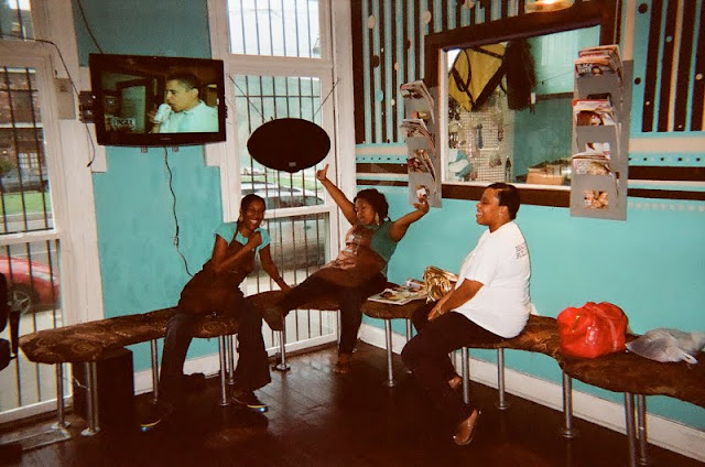

“It is really a multicultural salon – we service just about everyone and every ethnicity. It’s our home away from home because we are here more than anywhere else. I purchased this building with my husband in 2004, and decided to open the salon because I believe when people look good, they feel good, and that’s what this business is about.” - Janice Meredith, CEO of Simply Divine Salon. Photo by Janice Meredith.

Those who partook in the project gained a fresh sense of ownership over their community. I witnessed this effect when Kine showed me photos of trash strewn across the street and discussed how to make the area cleaner, when Rodjna discussed the meaning he found in specific graffiti tags along Broad, and when Toney said that the future development of Broad was important to him because it would allow him to do what he does best – cut and style hair.


“I don’t want to live off of McDonald’s or Burger King my whole life. It’s unhealthy. I like to see the faces of the customers when they walk out. You can tell if someone enjoyed your cooking and if their belly is full.” - King Sanchez, Student at Liberty's Kitchen - a unique cafe and food service training program. Photo by Genero Grinds.

Ultimately, I collaborated with BCC, project participants, and MIT CoLab to display the photos and digital stories in a vacant storefront as a community art exhibition. The show allowed the photographers to meet one another, as well as share their perceptions of their environment with a larger audience in New Orleans. The street became more than buildings and addresses; it gained a personality and an identity.


When planning neighborhoods and figuring out how to improve streets such as Broad, city officials, planners and architects generally observe an area with their own eyes – taking pictures with their own cameras, using research to validate assumptions based on their perceptions. This project and exhibition flips that model. The Broad Street Story Project intends to show Broad Street through the eyes of those who understand it best, and to give them space to bravely showcase their thoughts, ideas, and concerns to the public. These sorts of long-term effects are important because a successful commercial corridor relies on the attitudes, visions, and work ethic of its employees and users.

To learn more about the Broad Street Story Project and follow the digital story series, visit "Who's on Broad?" at CoLab Radio.

Shenzhen: Villages in a City

by Natalia Echeverri


Sheraton and Gangsha Village/City, Shenzhen.

Shenzhen is known as the city that was "built over night." It is a case in which growth outpaced politics, leaving behind an anachronistic urbanism. Its urban landscape began to change after Deng Xiaping introduced capitalism by creating the Special Economic Zone in 1978. Although, before Xiaping, Mao had passed a law by which land was owned by the state in the cities, in the rural areas, it was owned by the farmer collectives. This law had great impact in the way the city grew.


Figure ground of two "villages within a city" in the urban context.

Before the Special Economic Zone was implemented, the area of Shenzhen was composed of several farming and fishing villages. After the economic opening of 1978, Shenzhen's cheap land and its proximity to Hong Kong attracted foreign investors and land speculators. Their expanding developments quickly engulfed the existing villages. The population increased 400 times in 22 years. Since the farmer collectives were the owners of the land, the villages did not disappear with the fast urbanization. They resisted to be bought by developers or by the local government, which would have destroyed them to create new developments, since the land became so valuable.


"Hand Shake" Street and VIC lively alleys.


These “villages within a city” (VIC), as they are now called, have defied the industrial city’s speculation boom, although they have undergone their own special type of expansion. With the rise in land value and their proximity to city jobs, the existing one-story dwellings have extruded to 7 stories, occupying the entire lot in which they were built originally. The streets remain the same, very small, looking more like alleys between tall buildings, and in some cases the buildings are so close together that they are called “handshake” streets.

Currently, there are 241 VIC, spread across Shenzhen, 67 of them are in the Special Economic Zone. They mostly house the migrant population. However, the city is running out of land; “from a total of 195,284 hectares in the city, only 2.23% is still available for use” (Feng). Therefore, real estate prices have skyrocketed making the VIC land more desirable.


I see the VIC as a positive phenomenon, an example where a speculative boom consolidated a community and a social fabric. Each village in the city has its special gate, which differentiates it from the others. Inside, you really feel a city life. They offer cheap housing and a sense of community and belonging, as opposed to other areas of Shenzhen like the Overseas Chinese Town, which is a mix of theme parks, gated communities and golf courses.


Theme park and gated community in Overseas Chinese Town.

Unfortunately, these “villages within the city” will soon disappear because property rights are not legally inherited and the government is already trying to change the existing property laws. However there are architects, like Urbanus, who are exploring the fine grain that makes these villages so vibrant. This is not common in most of the new developments.


Credits: Photos of Shenzhen and diagram of VIC by Natalia Echeverri.


What is a City Without Sound?

by Min Li Chan

The city is often associated with the noisy, clamorous, cacophonous, and loud. And yet the notion of a city is almost instantly recognizable by its iconic soundscape - the breathy roar of a passing subway under your feet, the layered honks of taxis stuck in rush-hour traffic, the collective chatter and feet on sidewalks. Which brings us to a briefly indulgent thought experiment - what's a city without sound?

Perhaps sheer visual delight. An online community has congregated around "Cities in Minutes", a project which captures and showcases cities in minutes, using time-lapse photography with filmmakers, video enthusiasts around the globe. Here's a taste of one of the contributions, an ode to Tokyo:


My Tokyo from schnobe on Vimeo.

In a similar vein, the story in "Round About Five", a film short by the Guard Brothers, unfolds almost entirely without the soundscape associated with its visual narrative through London. A man, who nearly forgets to pick up his beau from the Eurostar station, rushes through what you could conceive as a crowded, cacophonous, congested rush hour in Londontown in the auditory imagination (even in the absence of actual sound). He's first despondent on foot, then elated on the back of a bicycle. We see London whizzing by, soundless but not without feeling a similar exultant joy.


But even in these examples, the visual delight is not entirely mute. A soundtrack fills the void in place of the city's native sounds. When we think about urban placemaking, we often talk about the physicality of space and our role in it. And as much as our perception of space is arguably visual, perhaps it pays to ponder how we want our world to be in sound.

Credits: Video of "My Tokyo" from "Cities in Seconds" on Vimeo, "Round About Five" on YouTube.

‘StickyWorld’ and an Alternative Approach to Democratic Design

by Andrew Wade


Image of a traditional design review in a school of architecture

A new web 2.0 platform, StickyWorld, has been created to further the democratic design agenda of innovative practice Slider Studio. This online design review platform essentially eases communication and transparency in the design process by creating the virtual equivalent of a design critique, client or contractor meeting, or project review with consultants.

While many architectural offices and design professions share graphic content through file transfer protocol (FTP) sites, StickyWorld allows multiple stakeholders to post drawings and comment on design options for others involved in the project to see. These virtual meeting places take place in "rooms" setup in the online account, each of which can be seen by included members. Permission levels (such as the ability to view content, comment on content, and post new content) are controlled by the administrator of each "room".

Screenshot of Slider Studio's StickyWorld platform in use during design of the Collaboration Café at The Building Centre 

This open source, collaborative environment not only sets the various stakeholders of a project on more equal footing, but it allows for feedback to be incorporated in an incremental design development process. StickyWorld operates especially well during the early, formative stages of a project, when key diagrammatic decisions are being made before being developed in more detail. In between physical meetings with members of the community, the client or consultants, the continuous thread of activity in the virtual meeting room of StickyWorld allows the workshop atmosphere of a design studio to be made more public if desired, allowing key parties to witness and comment on the evolution of a project. In addition, this format keeps a running history of items posted, comments made, and incorporated feedback which may be revisited at any date.

A strategy employed by Slider Studio to achieve greater collaboration in design has been to cross-pollinate the production of architectural design and software development within the same studio. Architects and software engineers work side-by-side to generate technology that specifically addresses the communication flows of design projects, rather than allowing the design process to conform to, or be generated by, the constraints of the adopted drafting and modelling software. StickyWorld has been tested and refined by four architectural practices in previous months: Make, Scott Brownrigg, HTA and Edward Cullinan Architects. The new version will be launched in March 2010 at the Building Centre in London.

Do you think the StickyWorld platform could further provoke the disintegration of an antiquated structure that divides designer/producer on one side and client/consumer on the other?  To what extent can such a holistic forum promote a more inclusive and democratic design process?

Credits: Image of design review from flickr user super.heavy. Image of StickyWorld screenshot from Slider Studio.


Featured Quote: Marie-Eve Morin


"As we are now faced with environmental crises, it becomes obvious that our unilateral polluting actions are being recoupled with their effects. As our management and regulation of the atmosphere is now part of our social and political concerns, the atmosphere can no longer be seen as an exterior but has effectively been integrated within the system of human relations."

Marie-Eve Morin, from "Cohabitating in the globalised world: Peter Sloterdijk’s global foams and Bruno Latour’s cosmopolitics," in Environment and Planning D: Society and Space, 2009

This is part of a collection of quotes related to cities. They don’t necessarily reflect our views, just topics of interest. We welcome you to add others.

Photo of smoke stacks from the Hunter College Department of Geography.

Open Source Cities

by Peter Sigrist


Site of the Greater Gansevoort Urban Improvement Plan, photo by Lily Bernheimer of TOPP.

Meaningful community input in urban development is often called for and rarely achieved. Recent posts at faslanyc, mammoth, varnelis, theincrementalhouse, urban omnibus, and cityofsound consider exciting possibilities. David Harvey and Robert Reich envision new forms of development, and Haiti Rewired shows the potential in sharing ideas and technologies. The Open Planning Project (TOPP) combines many of these elements, strengthening civic engagement in urban policy, planning, and design.


Opening frame from a video on "Physically Separated Bike Lanes" by TOPP's Streetfilms initiative.

Mark Gorton (founder of LimeWire) started TOPP in 1999. His goal was to promote alternatives to automobile dependency. While maintaining this focus, TOPP has become a kind of incubator for projects that support open participation in urban development. Their approach is rooted in the idea of open source, most commonly associated with free computer programs that can be shared, adapted, and further developed by anyone with the ability to contribute. While TOPP has much expertise in programming, they’ve also applied the open source model to urban planning and governance. With projects ranging from Portland's TriMet transit system map to the closing of Times Square to traffic, TOPP has been using technology for public work in many creative ways.


A view from the lawn chairs around Times Square, photo from Design You Trust.

Gorton’s background is unique in the world of community development. With degrees in electrical engineering and business administration, he spent nearly 5 years as a trader at Credit Suisse before leaving to found Tower Research Capital in 1998. His software-based approach to trading proved highly successful, and he earned a great deal of money without abandoning his bicycle commute to the office. After many close calls on the streets of Manhattan, he decided to pursue transportation reform in addition to his work in finance. TOPP is now an impressive group of programmers, designers, planners, writers, and activists. They operate as a nonprofit with mutually reinforcing concentrations in good governance, civic empowerment, and transportation planning.


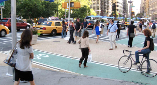
The new crossroads at Madison Square Park, photo from TOPP's case study on Creating Thriving Public Places.

TOPP helps government agencies share data, improve services, and save money through a combination of flexible software and tech support. Their work in this area includes Open311, an initiative aimed at helping people connect efficiently with municipal information and services; OpenGeo, a software platform that facilitates shared geospatial data; and TOPP Labs, a development engine for new technologies in support of local governance. They helped Landgate, a government agency in Western Australia, adopt open source software to transfer data seamlessly between departments. They've also worked with the Michigan Tech Research Institute (MTRI), whose clients include the EPA and the Bureau of Land Management, to improve their GeoServer data system.


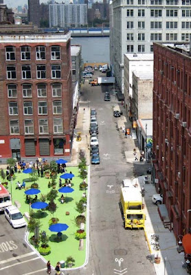
Rendering of a plan for the Pearl Street Triangle, composite image from susty.com.

In addressing civic empowerment, TOPP provides strong support for local efforts to influence policy and public opinion. They use programming, journalism, and multimedia design to communicate on a variety of levels. They've developed CoActivate, an open software package that integrates blogs, wikis, groups, mailing lists, and file storage; Community Almanac, a forum and archive for collaborative storytelling; GothamSchools, an information source for teachers, parents, and policymakers dedicated to improving city schools; and UncivilServants, a community-based monitoring system that helps prevent drivers from parking illegally on congested streets. TOPP has also been a key participant in New York's public plaza initiative, helping to convert a parking lot on Pearl Street into a public resting place with shaded tables and plantings.


Pearl Street Triangle before and after, photos from TOPP's case study on Amplifying Citizen Voices.

TOPP's Livable Streets Initiative works to counteract automobile-centered development and promote ecologically sensitive transportation options. They provide a range of tools for political mobilization, collaboration, and information sharing. Transportation projects include Streetfilms, which produces edutainment on topics from BRT to bike sharing; the Streetsblog Network, a collective of over 400 sustainable transport blogs; and Streetswiki, a community-driven archive of transport information. As part of the Streets Renaissance Campaign, TOPP participated in the adaptation of Madison Square Park to better accommodate traffic, bicyclists, and pedestrians (see "new crossroads" photo above). They're currently working on a similar plan for Grand Army Plaza.


Grand Army Plaza, photo from designtrust.org.

The results of TOPP's work show that open source technology can be used effectively for democratic participation in urban development. They've focused primarily on local projects, but their influence has reached national and international levels. The open source concept enables them to draw upon the contributions of many participants in a continuous process of experimentation and improvement.


Rendering of the plan for Grand Army Plaza, photo from TOPP's case study on Transforming Public Places.

While it's great to see such a remarkable team dedicated to civic action, some questions also come to mind. Could TOPP be a model for employment on a larger scale? Are they adding the kind of value that can be sustained financially without philanthropy? Does their work tap into the interests and contributions of people who don't come from relatively privileged backgrounds? How can they assure that it reflects the priorities of most local residents? Is this possible? Would they be happy with the results? I don't mean to criticize TOPP's inspiring work, just to consider how it might inform new approaches to civic improvement.


Participants at the New Technology for Participatory Planning workshop sponsored by TOPP and the Regional Plan Association, photo from The Civic Hacker.

To my knowledge, TOPP hasn't yet developed a grassroots funding mechanism for urban development. This could make smaller civic projects less dependent on large donors, corporations, and government. Faslanyc's PayPal idea offers a way for us all to contribute directly to the ideas we'd like to see realized. It would require a completely accessible, accountable, and secure online system, which sounds difficult but promising. There would also have to be a way to make sure that people with less money don't have less influence. Maybe something similar could be used for all kinds of public decisions, eventually taking the place of government representatives and making democracy completely direct. While there are many things to resolve along the way, I hope we're heading in that direction. Organizations like TOPP make it seem possible.

Participatory Budgeting

by Jordi Sánchez-Cuenca

Planning urban development and managing urban areas is simply too complex to be left to a small group of decision makers and professionals. Top-down decision making, even within representative democratic systems, was never a good system when it comes to responding to real needs and opportunities for development, or to preventing or sorting out social injustices. Indeed, citizens around the world have experienced all sorts of clumsy despotism and counterproductive visions of "ideal" societies. In their best performances, top-down styles of urban planning and management have created stable forms of social inequalities.


The Americas, with its 500 years of uninterrupted colonization, has been for centuries the ground for experimenting all imaginable development models. The Latin part of the continent is where imposed development experiments and colonization has been most traumatizing. In the last 20 years or so many Latin American cities, tired of suffering from repeatedly imposed useless, when not unfair, forms of development, have been breeding social movements aimed at putting an end to such imposition. The most successful creation by these movements has been a democratic urban management tool called Participatory Budgeting (PB).


It all started at the end of the 1980s in a few cities in Brazil, where organized neighborhoods joined as decision makers in the processes of allocating municipal budget for public works. Ten years later there were 100 cities in Latin America applying PB, and some of them were deciding large percentages of the municipal budgets in participatory assemblies. Today, 20 years after the first experiences, more than 1000 municipalities around the world have followed the example of the pioneer Latin American cities, each one applying it in their own way and for different sorts of public spending. Southern Europe is where the influence has been strongest, and some have called this phenomenon as the "Return of the Caravelas," the ships that were used by Spaniards and Portuguese to travel to subdue the Americas to European rule and culture; although this time cultural influence is taking place without violence. The influence has been such that some towns in Europe decide 100 percent of their budget in a participatory manner, including their mayor’s salary. And it works.


It has been demonstrated by several studies from the most internationally renowned universities that PB effectively helps reduce inequalities, tax evasion and corruption. Today, the movement is officially supported by the UN, the United Cities and Local Governments and many NGOs, and applied in several international networks of cities. The coming World Urban Forum will host a Networking Event where trends and the latest experiences with PB will be debated by experts from around the world.

Credits: Image of a PB campaign in the UK from www.communities.gov.uk. Image of a PB campaign by ActionAid. Image of a participatory assembly in Porto Alegre, the first Brazilian experience in PB, from www.iadb.org. Image of a participatory assembly in Sao paulo from www.amparo.sp.gov.br.

Jižní Město: Reviving Prague’s Largest Housing Estate?

by Melissa García Lamarca

Jižní Město, meaning South Town in Czech, is a sprawling housing estate of large, chunky apartment buildings colloquially known as panelák at the southeast end of Prague’s red metro line. Planned in the 1970s, it is a quintessential example of housing estates built in the Czech Republic and Slovakia when the areas were under communist rule. Jižní Město is indeed famed as the largest panelák housing estate in Prague, with 200 buildings built since the 1970s.


Walking through the area, the landscape is dominated and even absorbed by panelák, these blocks of high-rise panel buildings constructed of pre-fabricated, pre-stressed concrete. The buildings remain a towering, highly visible reminder of the Communist era, built after World War II with the goal of solving, efficiently, the pressing housing shortage. Indeed, panelák are in no way unique to the Czech Republic or Slovakia but were built in all communist countries, from Poland to Mongolia. According to census statistics, roughly a third of all Czechs (3.5 million people) and half of all Praguers live in paneláks.


While about 80,000 people currently live in Jižní Město, the fact that only a few thousand workplaces are located in the area makes it popularly known as ‘Prague’s bedroom’. During my visit on a cold winter day last week, I saw several children skidding across the new fallen snow in the open spaces in the middle of the complex, an area between the metro stops Háje and Opatov known as ‘Central Park’. Yet Jižní Město in its totality gave me a feeling of emptiness, a sparse and forlorn development devoid of soul or vibrancy. There are no pedestrian-accessible shops for people living on the estate, looming structures that have no human scale abound and several abandoned, squat structures dot the area.


Interestingly, the French social anthropologist Laurent Bazac-Billaut carried out an ethnographical study of panelák dwellers, specifically in the Jižní Město housing estate. Bazac-Billaut concluded that, despite the clichés about the anonymity of the over grown 'rabbit hutches', the quality of life on panelák estates is often better than it might first appear: people generally know their neighbours, social networks exists and public transport runs regularly.


A major finding of Bazac-Billaut's research is that panelák life is based on an intense drive for privacy and individuality. He notes that inside the standard panelák flats, identical in layout and to thousands of others the length and breadth of former Czechoslovakia, the key impulse of Czech panelák residents is to create their own private worlds.


For me such information begs the question, how can such individuality and a warm or inviting sense of place one finds in a home environment be brought into the surrounding urban fabric? The Czech urban philosopher Václav Cílek has advised the best way to revive the country's panelák neighbourhoods is by filling in the existing dead spaces, for example introducing variety through building lower structures among the high rises and opening shops on the floor level of buildings to help create street life. Plans exist to revitalise Jižní Město and many other housing estates across the Czech Republic, and it will be interesting in years to come to see how the multiplicity of challenges brought by the looming panelák forms are addressed.

Credits: Collaged image of Google Earth and aerial view of Jižní Město from Google Earth and Hynek Moravec, Wikipedia, respectively. All other photos by Melissa García Lamarca.

The Feminine Skyscraper

by Katia Savchuk


Aqua, a new 82-story residential skyscraper in central Chicago that has received attention for its unusual wave-like facade, has been equally fêted for being the world's tallest building designed by a woman. Architect Jeanne Gang had never designed a skyscraper and was handed the task by chance.

In a recent review of the project in The New Yorker, Paul Goldberger urged people to focus on the project's architectural merits and eschew "predictable interpretations of skyscrapers as symbols of male identity." We live in a physical environment that is overwhelmingly manmade (literally); most projects are judged as products of individual designers, in reference to the field, rather than taken as symbolic of the sensibilities of half of humanity. It is unfair to draw conclusions about the "feminine aesthetic" on the basis of one individual's portfolio - or even a handful.

Yet, one can't help but notice the building's frills and delicate curves against the skyline of its angular male-designed counterparts. What do you think: Do men and women design differently? Or are the differences individual rather than gender-based?

Credits: Image of Jeanne Gang from Studio Gang. Image of Aqua from The New Yorker.

Alternative Winter Commute

by George Carothers

Cities have provided people with inspiration and opportunity throughout history. During a recent trip to Ottawa I was able to experience how Canada's capital is offering it’s own inspiration for a planet under siege by traffic congestion and global warming.

Ottawa is home to a number of iconic cultural and historical sites, including the world’s longest skating rink, the Rideau Canal. The canal was opened in 1832 after growing concerns over Canada’s military strength and vulnerability during the War of 1812. An artificial waterway was required to provide a secure supply route between Montreal and the naval shipyards at Kingston. The solution was to construct a 202-kilometer (125 mile) canal that would bridge the gap between Ottawa and the foot of Lake Ontario.


Since 1971, during the winter months a “small” section of the canal has been groomed for use as an ice rink. The frozen 7.8-kilometer (4.8 mile) artery acts as a tourist destination, recreation venue, and more interestingly, a commuter "skateway" for local residents moving to and from work, school, and downtown facilities. The canal freezes naturally into a 30cm (12in) - thick sheet of ice, providing secure structural support for thousands of skaters. The ice is flooded and groomed through a series of holes punched through the surface, making use of the water below. The morning rush hour is cold, although active, as workers, university students, residents and visitors glide along the historic canal to the office, classroom, or downtown café.

Although commuter usage is not exactly high, the venue provides for an interesting alternative to the car, bus, bicycle, and even running shoe. Northern urban centers with historic canal systems should take note.

Credits: Photo of Rideau Canal from Intiaz Rahim.


Street Sounds U.S.A.

by Vivien Park


Part of the intrigue of a city is the layers and texture of its sound. Each region tends to contain a degree of variation that reflects the uniqueness of its inhabitants. As a way to capture these moments of our lives, the Smalls, an independent film and music curator and promotor, has recently launched an interactive sound collaboration project on the web.
The Sound Map is an interactive tool developed specifically for The Smalls Street Sounds, which invites the public to share the sounds of their environment by uploading their own recordings, along with a brief description and a picture. These recordings can be anything from the rumble of the local train to neighbors speaking in a foreign language, or the sound of kids playing baseball in the neighborhood park to a protest demonstration or simply the sound of the wind in the trees. Uploaded sounds are made available to other users of the Sound Map, and users can easily search for inspiring sounds via keywords or by navigating the map geographically.
The site has just entered its second phase and opened a call for entry for its filmmaking competition. Using sounds shared on the site, filmmakers, artists, and musicians are invited to make original short film inspired by one of the competition's four themes. The deadline for entry is March 26, 2010.

Credits: Image from The Small.

Paolo Soleri: Idealism Deferred

by Ali Madad

The lure of the radical architect and thinker, Paolo Soleri, culminated in my visit to his Arizona laboratory in mid-2005. Arcosanti is an embodiment of Aristotle's notions of: theoria, poiesis and praxis. However at 3% completion, it remains a dream deferred.


I came to know the work of Soleri through his association with Frank Lloyd Wright and moreso through his writings and drawings. The 1971 David Hall designed, Visionary Cities by Paolo Soleri, was a tantalizing presentation of the form/content — an expression, a glimpse into an alternate model of being.


With the amount of information written about or by Soleri, I won't attempt to restate his ideas. For me the lasting resonance is his realizing of 'paper architecture,' the pragmatic strain of idealism and the embodiment of belief and value in form and idea.


Credits: Photos of Arcosanti by Ali Madad.

‘Libro al Viento’ (Book on the Wind) and Other Mobile Books

by Natalia Echeverri


Recently, while taking the Bart, I found a new type of public library in the Cerrito Station. It is a book vending machine called Library-a-Go-Go which caries about 400 popular titles. You just have to be a member, swipe a card and your commute becomes more pleasant. This library system operates in transit stations, shopping malls and under-served areas in the suburban landscapes.

The model for these book vending machines was created in Sweden, but one can find other innovative public library systems for mobile people all around the world. Santiago, Madrid, Sao Paulo and Bogota have the bibliometro (metro-library) or biblioestacion (station-library) in busy transit hubs. These public libraries are larger than the vending machine carrying around 1500 books and are also much more personalized. The goal for these libraries is to give access to books to everyone.


Madrid "Bibliometro."


Sao Paulo "Embarque na Leitura" at estacion La Luz.

In Bogota, millions of books circulate around the city through the Transmilenio, the well-known BRT through a different program. It is called "Libro al Viento" (books on the wind) and was created to promote readership all around the city. The books are free, but their motto, which is written in the back of every book is: "this is a 'libro al viento,' it is for you to read and for others to read as well. For this reason, you should return it when you are done and take another one."

Since 2004, 54 issues of classic literature have been published which sum up to 4 million books. The books have also been distributed to public schools, hospitals and several public spaces. They are now more difficult to find because many readers have never returned them. However, the program is successful because it has brought free books to public schools.

More recently, the city of Bogota began with a system of "biblioestaciones" (library stations) on the Transmilenio transit system. These now control the use of the "libro al viento"as well as many other titles.

Like the BiblioBurro, these are low-key library systems that are helping spread knowledge and culture all around.

Credits: Image of Library a-Go-Go from libraryjournal.com. Image of Bibliometro Madrid from blog.bellostes.com. Image of Sao Paulo metro library from gomesnaldo.wordpress.com. Image of Libro al Viento from Natalia Echeverri.

A View of Haiti from Liberty City

by Hector Fernando Burga


We can usually rely on the lines we draw. I pick up my pen and with determination put marks upon the paper. This is often the starting point of an extended creative process that balances delicately between intellectual rigor and aesthetic pleasure. With the sketch, in studio, we are in a zone we can control, a place of direction, maybe even refuge. And with the unfolding work there is always tomorrow.

But like so many of us, in the past weeks I haven't been able to take the pen and draw with purpose. I’ve become one of millions of spectators to the unfolding catastrophe in Haiti, and I am driven to write about a place whose struggles can’t really be drawn or envisioned in plans, whose suffering reveals the comparative inadequacy of design before the immediacy of death and destruction.

This is not a comfortable place to be at or to speak from. It doesn’t provoke quick solutions or prescriptions. So with humility, and unable to just draw, I want to ask: what can I do? Where do I start.

To read the rest of the story, please go to http://places.designobserver.com/entry.html?entry=12677.

Credits: Image from UNDP.

Featured Quote: John Ruskin


“Through sanitary and remedial action in the houses that we have; and then the building of more, strongly, beautifully, and in groups of limited extent, kept in proportion to their streams and walled round, so that there may be no festering and wretched suburb anywhere, but clean and busy street within and the open country without, with a belt of beautiful garden and orchard round the walls, so that from any part of the city perfectly fresh air and grass and sight of far horizon might be reachable in a few minutes’ walk. This the final aim.”

John Ruskin, from Sesame and Lilies, 1865 (as quoted by Ebenezer Howard in Garden Cities of To-Morrow)

This is part of a collection of quotes related to cities. They don’t necessarily reflect our views, just topics of interest. We welcome you to add others.

Credits: Photos of Cambridge, England, by Peter Sigrist.

By the Time I Get to Arizona

by Alex Schafran


View Larger Map

Yuma, Arizona is a border city in multiple ways. Google's satellite imagery captures much of it - the line between the actual desert and the irrigated one; the wall between the actual Mexico and the former one; the space between the Golden State and the Grand Canyon state. It is a fitting place to enter the incongruity that is urban Arizona, a hyper-modern state that seems stuck in the Reagan era.


Tucson is at the heart of the southern swath of blue which sandwiches the redness of greater Phoenix, a multi-flavored politics which makes Arizona undoubtedly purple, John McCain and Janet Napolitano par example. There is a touch of both old and new urbanism to Tucson, historic buildings that mesh with renovated adobe and the funkiness of the overgrown college town which it tends to resemble. But it is the street which one notices right off the bat - every one of them, even the smallest of side streets, seems big enough to park a semi at a 90 degree angle.

It would make sense if the streetscape in urban Arizona was designed around large SUV's, for they are so ubiquitous that the shift from the bourgeois bicycle and Prius roadways of Oakland is stark. When combined with Styrofoam plates and intermittent recycling, it feels like being transported back in time.

Yet nothing in Tucson can truly prepare you for Phoenix, an almost legendary multiheaded metropolis with astronomical population growth and enough Boomburbs - i.e. Mesa, Chandler, Glendale - to keep Robert Lang in business for decades. The city grew by a million people between 2000 and 2008, a growth rate set decades earlier when Phoenix spent the last 20 years of the past century as one of fastest growing metro regions in the nation. There is a potent mixture of sadness and irony that Detroit lies just one spot ahead of Phoenix in the rankings of largest US metros (11th and 12th respectively), and one can imagine where that is heading.

Or is it? Phoenix, despite it's truly marvelous freeways (driving on them is like butter; I think they have redefined merging), the Phoenix miracle has hit the skids. There is talk that population growth may actually be declining, hammered by a skyrocketting foreclosure rate and an economy seemingly built on the building of Phoenix. It's dependency on automobile transport (less than 2.5% of workers commute via transit) and the construction economy (more than 10% of the workforce, not including all the real estate and mortgage brokers now looking for work) have left it vulnerable as the "Ponzi scheme that works" seems to fall apart at the edges. While the supposedly modern Los Angeles works to reinvent itself yet again as the next American metropolis, Phoenix, the true post-war city built on cheap flat desert land around a magnificent grid of freeways and affordable subdivisions, may be running aground.

Yet all is not necessarily lost. Hidden between the spectacular mountains and smog-chocked skies are the odd green shoot of a new city, a potentially bikeable city with a fledgeling light rail system, a few smidges of anti-corporate culture and a legitimately fantastic public art scene. There is even the odd protest of Maricopa County's proto-fascist Sheriff, Joe Arpaio, a fact that must be taken alongside events such as the recent Scottsdale Tea Party rally in favor of coal-fired power plans and against emissions rules. If another city is possible, let's hope it manages to get to Arizona, or even better, that Arizona manages to reinvent itself.


Credits: Image of Arizona by author. Map of Arizona embedded from Google. Video of Public Enemy embedded from the YouTube, of course.