

by Ivan Valin


In her post last week, Natalia described the problematic developments occurring in the periphery of Cairo, where suburban mega-developments are siphoning investment and water from urban areas in dire need of both. Natalia shows that in the vastness of the desert, neoliberalism looks like an ample, green sprawl. But Cairo has another periphery--the Nile--and the same forces of private development applied here disrupt and erode the meaningful connections between the city and its waterfront.
 A map of Cairo from 1685 by Vaisseau Graviers d' Ortiees

A view down the promenade, even during the day, shows a well-used space, at all levels.


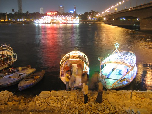
Barge and embankment constructions combine to block the view to Zamalek.
In short, as everyday Cairenes are facing disinvestment of infrastructure and housing resources, they must also now deal with diminishing access to the primary recreational, social, and spiritual corridor of the city. I am not arguing that the waterfront should be a single, accessible free zone--as this would be neither feasible nor desirable along the Nile's diverse edges. I would argue instead that a generous public right of way should be established and respected. It would define not only a dimension for circulation, but include allowances for near and far views, room for air and water movement, and even strategies for cleaning and maintenance.
But resourceful Cairenes have not waited for the government to free their space--they have already adapted by taking over the bridges that cross the Nile. Along the low-slung sidewalks of University Bridge, this new social space is at its most vibrant. Connecting from the residential areas around Abdeen Palace to Cairo University, this bridge draws on a large and young population. At dusk, vendors set out hundreds of cheap plastic chairs as the bridge fills up with people. Some are crossing, but many more are just there for the evening spectacle and cooling air. Grungy infrastructure becomes righteous public space.


Vendors on University Bridge make preparations for the evening.

In her post last week, Natalia described the problematic developments occurring in the periphery of Cairo, where suburban mega-developments are siphoning investment and water from urban areas in dire need of both. Natalia shows that in the vastness of the desert, neoliberalism looks like an ample, green sprawl. But Cairo has another periphery--the Nile--and the same forces of private development applied here disrupt and erode the meaningful connections between the city and its waterfront.
 A map of Cairo from 1685 by Vaisseau Graviers d' Ortiees
As an ancient city, Cairo was established at a safe distance from the Nile's broad floodplain. Laced with canals and strung with shadoofs, this buffer was also a productive agricultural zone. In the beginning of the 19th century, the city began expanding west towards the Nile and swaths of this land were drained and stabilized for occupation. In the 1950s, with the infill complete, the Nile Corniche--a public promenade at the water's edge--formalized the city's connection to the water. Inaugurated by socialist president Gamal Abdel Nasser, this space was originally intended to relieve overcrowding that plagued much of the city.
The Nile Cornish is still needed today. The lack of public open space in urban Cairo is extreme and well documented. The corniche still serves a vital role as a place of public gathering and collective release in the city. It is most active in the evenings, when the cool breeze coming off the water invites an almost promiscuous mood. Every surface, every railing, is occupied. Packs of slick young men strut along; multi-generational families eat a picnic-dinner; shy lovers find seclusion in the crowds; felucca pilots scurry up and down the fortified banks, soliciting loudly for rides.
The Nile Cornish is still needed today. The lack of public open space in urban Cairo is extreme and well documented. The corniche still serves a vital role as a place of public gathering and collective release in the city. It is most active in the evenings, when the cool breeze coming off the water invites an almost promiscuous mood. Every surface, every railing, is occupied. Packs of slick young men strut along; multi-generational families eat a picnic-dinner; shy lovers find seclusion in the crowds; felucca pilots scurry up and down the fortified banks, soliciting loudly for rides.
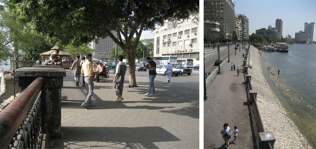
A view down the promenade, even during the day, shows a well-used space, at all levels.
But recently, a rash of private or exclusive developments along the Nile have systematically overrun this public space. With few restrictions and fewer planning documents, hotels, apartments, malls, social-clubs, pay-to-enter gardens, and restaurants interrupt the promenade. Fifty years ago, people cheered when the British Embassy's riverfront gardens (a plain symbol of colonial rule) were destroyed to make way for the completion of the corniche. Now, as entrepreneurs and developers capitalize on the Nile view and its cooling breeze, the corniche is in danger of being lost again.
The destruction of the corniche takes three primary forms:
The destruction of the corniche takes three primary forms:
- Territorial Extension: Where the offending interest exerts such an overwhelming presence on the corniche with guards, signage, or planters, that it cannot be occupied by anyone other than an invited guest. (I was repeatedly chased out of these areas, my camera and sketchbook being too suspicious.)
- Embankment Occupation: Where private space occupies the space of the embankment, from the cornice edge to the water's edge. If kept low, these buildings can allow a view across the river from the corniche, but often even this is screened with fences.
- Water Occupation: Where barges are parked in the water adjacent to the corniche. Gaudy and big, these boats block views as well and are often accompanied by a guard-shack on the corniche. If coupled with either of the above techniques, the effect is especially stifling.

Barge and embankment constructions combine to block the view to Zamalek.
In short, as everyday Cairenes are facing disinvestment of infrastructure and housing resources, they must also now deal with diminishing access to the primary recreational, social, and spiritual corridor of the city. I am not arguing that the waterfront should be a single, accessible free zone--as this would be neither feasible nor desirable along the Nile's diverse edges. I would argue instead that a generous public right of way should be established and respected. It would define not only a dimension for circulation, but include allowances for near and far views, room for air and water movement, and even strategies for cleaning and maintenance.
But resourceful Cairenes have not waited for the government to free their space--they have already adapted by taking over the bridges that cross the Nile. Along the low-slung sidewalks of University Bridge, this new social space is at its most vibrant. Connecting from the residential areas around Abdeen Palace to Cairo University, this bridge draws on a large and young population. At dusk, vendors set out hundreds of cheap plastic chairs as the bridge fills up with people. Some are crossing, but many more are just there for the evening spectacle and cooling air. Grungy infrastructure becomes righteous public space.


Vendors on University Bridge make preparations for the evening.
Credits: All photographs by Ivan Valin, many more here. Map of Cairo from 1685 by Vaisseau Graviers d' Ortiees from the Islamic Cities Map Collection.
